
Weather in the Arid Southwest
When puffy white clouds appear in the sky above a hot arid landscape, one may wonder “where is that moisture coming from?”. The desert southwest is unique in many ways and the weather patterns are no exception. We talk about weather with Tony Merriman, meteorologist and outreach coordinator from the National Weather Service office in Flagstaff, AZ. We discuss the large and small scale factors that contribute to the aridity and the (hopefully) moisture we have here on the Colorado Plateau.

Meet the Scientist:
Tony Merriman
Tony Merriman is the Warning Coordination Meteorologist (WCM) at the National Weather Service office in Flagstaff, Arizona. He serves as the outreach coordinator and is the primary contact for media inquiries and outreach events. Tony also is responsible for directing annual storm spotter training and acts as the liason between local and state government officials.
Follow Science Moab wherever you get your podcasts
Interview Transcript - Weather in the Arid Southwest

This week, we speak with a scientist whose head is in the clouds: Tony Merriman, the Warning Coordination Meteorologist for the National Weather Service in Flagstaff, Arizona. We cover the processes behind weather in the Southwest, severe weather, and relationships he and his team have built with the Navajo Nation to discuss weather across languages and cultures.
Science Moab: Why do we see so many clouds around here when this area has such low moisture and rainfall?
Merriman: There are several main ingredients needed for clouds and thunderstorms to develop. First, we need moisture. With clouds, we’re talking about moisture in the atmosphere. So it might be dry at the surface, but if we go up in the atmosphere a few thousand feet, it might have a higher dew point.
Then, we need another mechanism called lift; in the southwest, we have orographic lift, when air is forced up into the atmosphere due to the terrain. So if the air has enough moisture, and it gets forced up into the atmosphere by a mountain range or some kind of terrain feature, it can condense into clouds. So there’s enough moisture in the mid-levels of the atmosphere to create these clouds right now, but you’re not getting much, if any, precipitation out of it.
Science Moab: What determines whether we’re going to get a monsoon season?
Merriman: It’s primarily the overall weather pattern and the position of what we call mid-level high pressure. For a good monsoonal flow, the center of that high pressure is over north Texas. That’s a really good monsoonal flow, but it’s constantly changing. If that high pressure were to shift a little farther west and become centered over New Mexico or Arizona, which is what we saw last year, that monsoonal flow would actually go up over the west coast of California, and not over the Southwest. Wherever that center of high pressure is, that’s where it’s going to be hot and dry.
Science Moab: What causes the severity of the thunderstorms that we see with monsoons?
Merriman: The main thing that determines the intensity of thunderstorms is something called wind shear, which has to do with the jet stream. The jet stream during the summer months is displaced farther north. So you actually might see more severe storms in the northern plains and the East Coast. But in the southwest, because of the amount of moisture we get, and the short life cycle of these thunderstorms, they can rain out quite a bit in a short period of time. That causes flash flooding. Whenever it rains on rocks, or post-fire burn scars, not much rain is absorbed into the soil. The impacts are simply much higher out here, because of the rocky terrain, the flash flood threat, and low-water crossings.
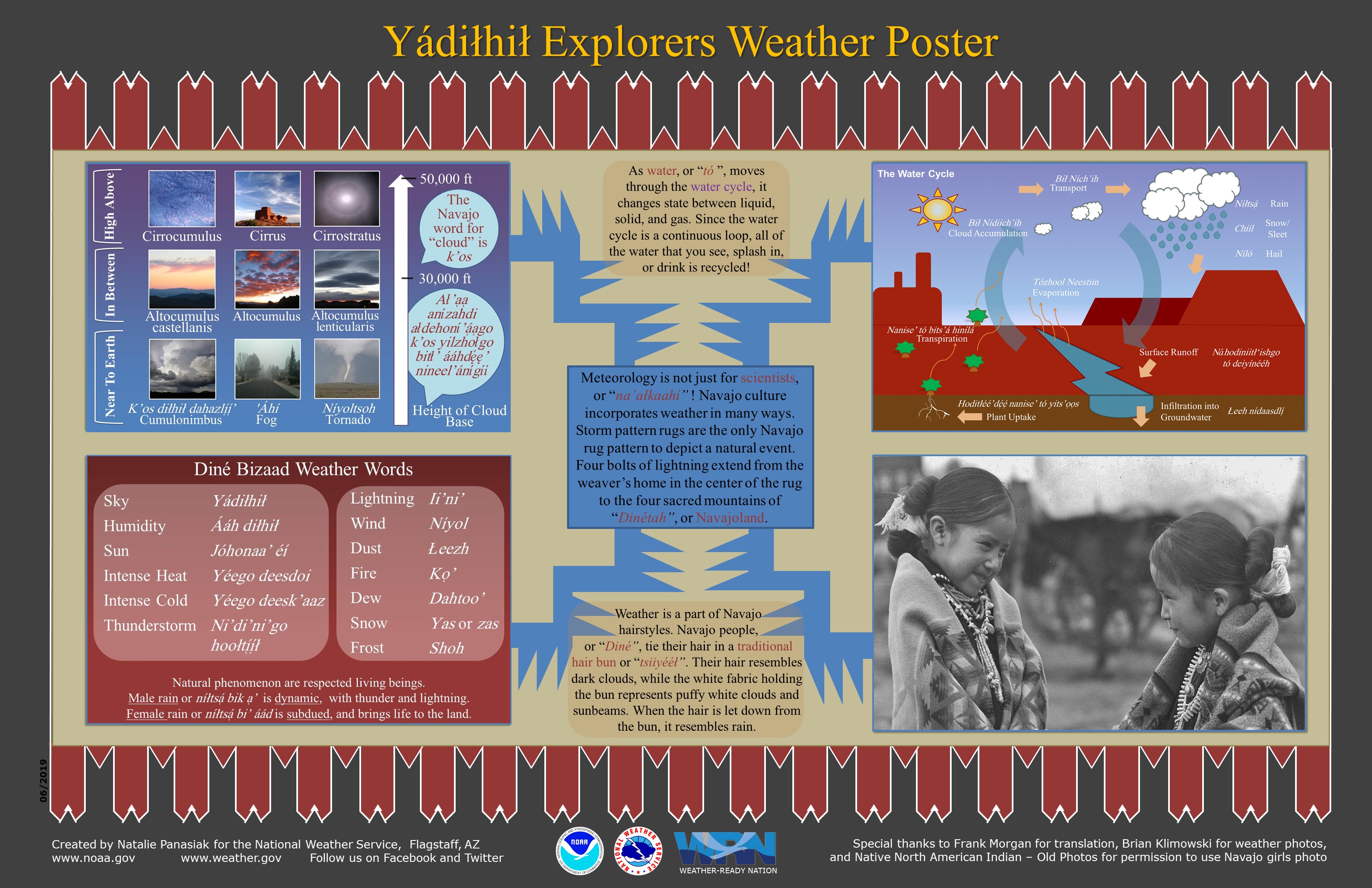
Science Moab: Tell me about your project with the Diné (or politically, the Navajo Nation), creating cloud charts that incorporated Navajo language into weather terms.
Merriman: We put out a project through the NOAA Hollings Scholarship Program to create a Navajo weather poster, and worked with the Navajo Nation for help with translation and design. We worked very closely to make sure that we had accurate words for different weather phenomena, and that we were keeping the traditions of Navajo Nation as well. It was a big project, and I was really glad we did it. We’re looking forward to working with maybe the Hopi tribe, or White Mountain Apache Tribe, to learn more about how their culture views weather and uses nature to predict the weather.
One example that our primary contact at the Navajo Nation uses is how elders will look at the height of ant hills to predict seasonal weather. If ant hills are very high before winter, then the ants are expecting a snowier year than average. Same with the monsoon season: if the ant hills are really high, then the ants are expecting a wetter than average monsoon season. The converse is true, too; if it’s a low anthill, they’re not expecting much precipitation at all.
Science Moab is a nonprofit dedicated to engaging community members and visitors with the science happening in Southeast Utah and the Colorado Plateau. To learn more and listen to the rest of Tony Merriman’s interview, visit www.sciencemoab.org/radio. This interview has been edited for clarity.


