
Studying Gravels
Sedimentologists are geologists that study rocks on the earth’s surface today in order to interpret ancient depositional environments. By studying deposits of river gravels, Andre Potochnik has been able to determine major changes in the drainages on the southern part of the Colorado Plateau. We talk with Andre about his work in Arizona on the Apache Reservation and how he has come up with the timing of significant drainage reversals for rivers in that area and how this impacts the interpretations of the Colorado River and the Grand Canyon.

Meet the Scientist: Andre Potochnik
Andre is a Flagstaff-based geologist, educator, and outdoor river/trail guide. His inspiration in geology and rivers stems from his long-time work as a Grand Canyon dory boatman. Andre earned his Ph.D. in geology from Arizona State University focusing on the uplift history and landscape evolution of the southern Colorado Plateau and borderlands. For fourteen years, he provided advice to the Department of Interior on the re-operation of Glen Canyon Dam for the benefit of the Colorado River ecosystem in Grand Canyon. With over ten years as a college lecturer and published author, he focuses his research on the origin and evolution of the Colorado River. Andre continues to enjoy skiing, hiking, photography while sharing his love and knowledge of the desert southwest with travelers and students from around the globe.
Relevant Links
Follow Science Moab wherever you get your podcasts
Interview Excerpt: Drainage Reversals on the Colorado Plateau
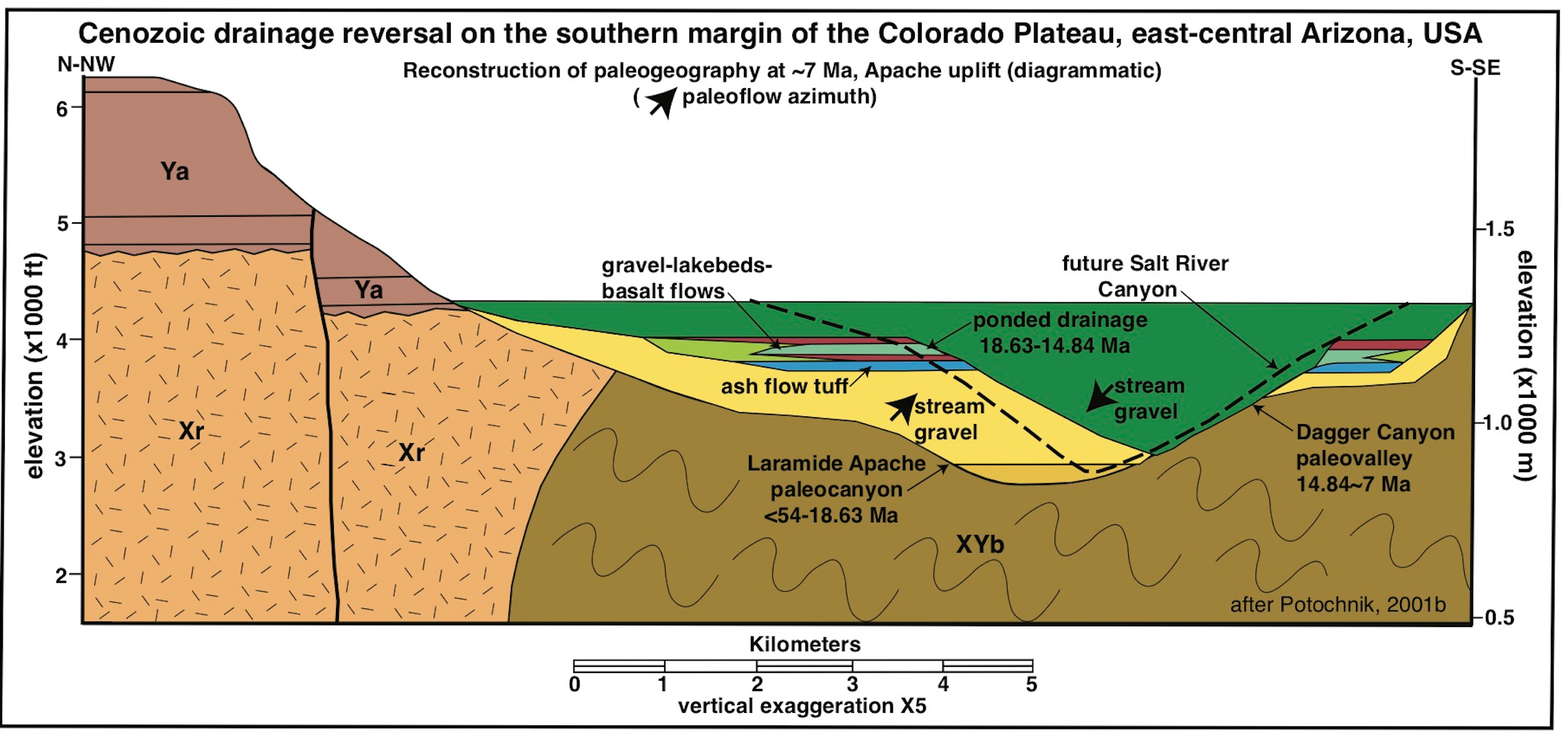
ScienceMoab: Can we start by having you set the scene of what the landscape looked like over the last 60 million years or so that led to these major movements in the earth’s crust and the ultimate reversal of drainage patterns on the Colorado Plateau?
Potochnik: Beginning around 80 million years ago, streams flowed from a large mountain range that existed south of the Colorado Plateau. These rivers flowed northeastward onto what is today the Colorado Plateau and probably ended up flowing all the way to the Mississippi River embayment. Around 30 million years ago, the plate tectonics situation changed between the Pacific plate and the North American plate in such a way that the compressional stresses on the continent, which had built the ancestral highlands inboard of the actual boundaries (San Andreas Fault) were released, and the continental crust then began to subside and spread out to the east and west. This caused the ancient mountain system we call the Mogollon Highland that was south of the Plateau to collapse and the entire southern edge of the Plateau gently flexed back down toward the southwest, causing the ultimate reversal of the drainages.
Science Moab: could you explain how studying deposits of ancient river gravels and terraces helps you understand the relative flow of ancient rivers?
Potochnik: Paleo current indicators that indicate the direction of flow can be ascertained by a couple of different methods. The principle one I use is called stream imbrication which is the layering of gravels of different sizes and boulders. These gravels represent movement along the channel bottom, and the movement of these gravels comes to a stop when the river flood that’s carrying them subsides. Since many of the boulders tend to have some flat dimension to them, they will tend to layer such that they are tilted upward in the direction of flow, which is the the angle at which they’re least likely to get transported further. by measuring hundreds and hundreds of measurements over a very large regio, I was able to piece together the flow directions for a given locality.
Science Moab: Most of your work was done in this Apache paleo Canyon, how can you apply it to say, the Colorado River drainage?
Potochnik: We know that these rim gravels exist on the rim of the Grand Canyon as well. Unfortunately, the Grand Canyon doesn’t preserve the deposits that help explain the drainage reversal like the Salt River Canyon does. What this study does is it documents deep paleo canyons, such as the Apache paleo Canyon, carved by north east flowing drainages that were predecessor canyons to modern drainages, such as the Salt River, which flows southwestwards through the Apache paleo Canyon. If ancient canyons were carved in the southern Plateau boundary in eastern Arizona, then why not in Western Arizona as well, because we also have the evidence for the ancient rim gravels in that area. I became very curious to see if I could apply what I’ve learned in the Salt River Canyon because the two regions (Grand Canyon and Salt River Canyon) are very similar geographically, and paleo geographically. The Mogollon Highland extended all the way across Arizona to the Grand Canyon region; clearly the Colorado River is passing through an ancient mountain system that collapsed in that region as well. One of the mysteries of the Grand Canyon is when did the canyon get cut? there was quite a discussion about this back in 2008, when Rebecca Flowers studied the uplift of the ancient mountain system, near the mouth of the Grand Canyon, and came up with some numbers for the uplift of the Mogollon Highland in that region of 70-74 million years ago. The implication was that there must have been a big uplift at that time and there must have been a big canyon cut into the southern edge of the Colorado Plateau in Western Arizona, suggesting that the Grand Canyon may have begun to be cut by ancient north east flowing rivers onto the Plateau from the Mogollon Highland at that time. When the Colorado River found its course off of the southern edge of the Colorado Plateau to the southwest, it simply flowed through the predecessor canyon that had already been carved, similar to what the modern Salt River has done. The Grand Canyon may well be a lot older than 6 million years.


